Temporary Rose and White Street Intersection Closure

Notice of Temporary Traffic Control Plan
E. Stadium Boulevard Bridges Replacement Project
September 24 – October 8, 2012

Location and Limits of Affected Area:Intersection of Rose Avenue and White Street

Description of Work:Intersection Reconstruction

Temporary Construction Traffic Control Plan:
September 24, 2012 – October 8, 2012 (Intersection of Rose Avenue and White Street)
The intersection of Rose Avenue and White Street will be closed to all vehicular and pedestrian traffic while the intersection is reconstructed.

E. Stadium Boulevard between Kipke Drive and S. Industrial Hwy. will remain closed to pedestrian and vehicular traffic until November 14, 2012 to allow for the removal and replacement of the E. Stadium Boulevard bridges over the Ann Arbor Railroad and S. State Street.  Vehicular and pedestrian detour routes are in place.

Temporary Washington Street Closure

Notice of Temporary Traffic Control Plan
W. Washington, from S. Ashley Street to S. First Street
Friday September 28, 2012 at 7:00 am thru Sunday September 30, 2012 at 7:00 pm

Location and Limits of Affected Area:W. Washington from S. Ashley Street to S. First Street

Description of Work:This temporary street closure is for placing a large crane on W. Washington St. for lifting parts to install a tower crane that will be erected on site W. Washington Street, between S. Ashley Street and S. First Street. W. Washington Street. Pedestrian traffic will be maintained on the north side of W. Washington.

Temporary Construction Traffic Control Plan:The eastbound traffic at the intersection of W. Washington Street and S. First Street will be detoured south on S. First Street, east on W. Liberty Street, north on S. Ashley and back to W. Washington.

The westbound traffic at the intersection of S. Ashley Street and W. Washington Street will be detoured north on S. Ashley Street, west on W. Huron Street, south on S. First Street and back to W. Washington Street.

Study on Rapid Flashing Pedestrian Beacons in St. Petersburg

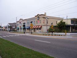
An uncontrolled mid-block crossing in St. Petersburg
This study was originally published on the website walkinginfo.org, and is republished with permission.  View the original post for more information or to contact the study authors.

Problem
Multi-lane, high-speed roadways made uncontrolled pedestrian crosswalks unsafe. The motorist yielding compliance rates were less than 2% overall at these crosswalks.

Background
Motorists often fail to yield to pedestrians in crosswalks. Many serious pedestrian-vehicle crashes happen at uncontrolled mid-block crossings. When motorists do stop for pedestrians, other motorists sometimes try to pass the stopped motorist. This situation can lead to screening crashes. The City of St. Petersburg, Florida has over 100 uncontrolled crosswalks, and as of 2003 its pedestrian injury rate of 49.23 per 100,000 people was higher than both the county's and the state's rates.

Solution
In 2003, the City of St. Petersburg listed enhancements to uncontrolled crosswalks as a top priority in its CityTrails - Bicycle Pedestrian Master Plan.

The same mid-block crossing equipped with
 the four-beacon RRFB system
At that time, a vendor offered to install a new traffic control device, the Rectangular Rapid Flash Beacon (RRFB), under crosswalk signs at two uncontrolled crosswalk locations. RRFBs are user-actuated rectangular amber LEDs that produce a wig-wag flash sequence to warn motorists to yield to pedestrians in the crosswalk. The City agreed to let the vendor install the RRFBs, and it conducted studies at the two crosswalks and analyzed the results.

RRFBs were an attractive alternative to traffic signals and hybrid signals because their cost of $10,000-$15,000 for the purchase and installation of two units was significantly less expensive than other options. The solar power needed to operate the LED beacons also reduced operating costs.

The City, under Permission to Experiment, compared pedestrian crossing compliance of the RRFBs to dual overhead round amber flashing beacons and side-mounted round flashing beacons at the two crosswalks. Both of these round beacons produced disappointing yielding compliance rates of 15.5% for the dual overhead round beacons and 11.5% for the side-mounted round beacons. The City experimented with two-beacon RRFB systems and four-beacon RRFB systems at the same crosswalks, for comparison. Four-beacon systems allowed for the placement of beacons in the center median, which gave motorists traveling on inside lanes of multi-lane roadways a better view of activated beacons. In all cases, there were yield markings at 30 feet in advance of the crosswalks that were used in conjunction with the RRFBs to alert motorists of upcoming crosswalks and to encourage them to stop in advance of the crosswalk to reduce the chance of a screening crash.

Results
The initial success of the RRFBs at the two crosswalks led the City to install 17 more RRFBs and conduct a two-year review of the 19 crosswalks, during which over 16,000 individual crossings were evaluated. As a result of this two-year study, it was determined that RRFBs led to sustained yielding over time. The baseline yielding percentage prior to the installation of RRFBs was 2%. The graph below shows the average yielding compliance results over time at the sites. Please note that the averages at 7, 30, 90, 270, and 365 days used data from all 19 sites, while the average at 60 days was compiled with data from 17 sites, the average at 180 days was compiled with data from 13 sites, and the average at 730 days was compiled with data from 17 sites.

The RRFBs performed equally well at night. One site at 1st Street just south of 37th Avenue North had a yielding percentage of 99.4% at night when using the four-beacon system. The yielding compliance rate was dramatically higher than the baseline nighttime percentage of 4.8%. This increase in yielding percentage at night can probably be attributed to LED lights being very visible at night.
(Graph created using data from Van Houten, R. and J. Shurbutt. Effects of Yellow Rectangular Rapid-Flashing Beacons on Yielding at Multilane Uncontrolled Crosswalks, Report No. FHWA-HRT-10-043, Washington, DC, September 2010) 

The research also showed that the four-beacon system produced a statistically significant increase in motorist yielding compared with the two-beacon system. The average increase in yielding from the baseline to a two-beacon system was 18.2% to 81.2%, while the four-beacon system led to an average increase in yielding of 87.8%. RRFBs improved the yielding distance as well. There was a 9% increase over the baseline in yielding at greater than 30 feet in advance of the crosswalk when using the four-beacon system, and yielding at greater than 100 feet in advance of the crosswalk almost doubled. Greater yielding distances made crosswalks safer for pedestrians because the pedestrians had a better view of approaching vehicles in all oncoming lanes. The increases in yielding percentages and yielding distances also led to fewer vehicles attempting to pass yielding vehicles.

The installation of RRFBs and advance yield markings greatly improved mid-block crossing safety in St. Petersburg. As of May 2012, the City of St. Petersburg had 42 RRFBs with advance yield markings in place with another 20 to 30 scheduled for 2014.


References
Van Houten, R. & Malenfant, J.E.L.. Efficacy of Rectangular-shaped Rapid Flash LED Beacons.
http://mutcd.fhwa.dot.gov/resources/interim_approval/ia11/stpetersburgrpt/stpetersburgrpt.pdf

Van Houten, R. and J. Shurbutt. Effects of Yellow Rectangular Rapid-Flashing Beacons on Yielding at Multilane Uncontrolled Crosswalks, Report No. FHWA-HRT-10-043, Washington, DC, September 2010.
http://www.fhwa.dot.gov/publications/research/safety/pedbike/10043/10043.pdf

Multiple Projects Launch Implementation of ReImagine Washtenaw


Head east out of Downtown Ann Arbor along Washtenaw Avenue, and you’re sure to notice some construction activity.  Across from Whole Foods Market, ground-breaking has begun on Arbor Hills Crossing, a 90,000 square feet retail and professional office development in the City of Ann Arbor.   The project includes new and wider sidewalks, a traffic signal and pedestrian crossing at Platt Road, and a new AATA Transit Super Stop.  Continue further east, and you’ll notice the Michigan Department of Transportation has begun a major traffic operations and non-motorized project at US-23.  The non-motorized component of this project includes the construction of new non-motorized paths on both sides of Washtenaw Avenue, which provide a way for pedestrians and bicyclists safe travel under the highway overpass.

“After years of planning and consensus-building, we are excited to see two projects that will significantly enhance walkability and pedestrian access to businesses in this important corridor,” said Ann Arbor City council member Tony Derezinski. “Over time, you’ll see additional improvements that even further increase walkability, provide a sense of place, and also increase property values.”

“The Michigan Department of Transportation is looking forward to continuing its collaboration with the ReImagine Washtenaw initiative, to ensure future improvements address both MDOT’s needs, and also the community’s vision for the corridor,” says Kari Martin, MDOT’s University Region planner.

Multiple projects are being implemented and coordinated between Pittsfield and Ypsilanti Township, including improvement/installation of pedestrian facilities, such as ramps, sidewalks, signals, and mid-block crossings, at Washtenaw and Golfside, zoning changes coordinated between both communities to allow for mixed-use development nodes, and lane reduction and bike lane installation along Golfside Road.

ReImagine Washtenaw is a multi-jurisdictional land use planning and public transit initiative to transform the corridor from auto-focused, to a safe, multi-modal, public transit-enhanced corridor, with new, high-quality mixed-use development, enhanced transit service and amenities, resulting in a corridor with sense of place.  Professional staff planners and elected officials from the Cities of Ann Arbor and Ypsilanti and Pittsfield and Ypsilanti Townships have been leading this effort.  Additional partners, including the Ann Arbor Transportation Authority, Michigan Department of Transportation, Washtenaw County, Ann Arbor/Ypsilanti Regional Chamber of Commerce, and the Washtenaw Area Transportation Study, are also collaborating to take the county’s most congested and auto-centric road, and turn it in to a high-functioning, multi-modal corridor.

For more information contact Nathan Voght, in the Washtenaw County Office of Community and Economic Development, at voghtn@ewashtenaw.org or 734-222-3860, or visit www.washtenawavenue.org.

Public Transit Benefits Article on Concentrate

Local online magazine, Concentrate, recently published an article discussing the health and livability benefits of public transportation. The piece features WATS Director Terri Blackmore, where she details some of the regional strategies to realize these benefits. 

From the article
In recent years, public health planners and leaders have begun to focus on improving transit systems as a community health opportunity. Washtenaw County transit planners have incorporated non-motorized options for several years and recently have begun to collaborate with public health officials on programs like the Washtenaw Area Transportation Study Clean Streets program, and other less formal efforts.

Linking public health with transportation decisions, however, has been a pretty recent development.

...
Read the rest of the article at Concentrate

SEMCOG/MAC Pulse of the Region Survey


SEMCOG and the Metropolitan Affairs Coalition(MAC) are inviting Southeast Michigan residents to comment of the region's transportation system-its roads, bridges, and transit-via an online survey.

In 2012, SEMCOG's local government members will decide on a long-range transportation plan and a list of the highest-priority projects to be funded over the next five years. As the plan is developed, there are many opportunities for input from the public. While SEMCOG and MAC encourage residents to talk to their local officials about priorities in their own communities, this survey will provide input on the regional level.

You can make additional comments via e-mail to InfoCenter@semcog.org, and stay up-to-date by watching SEMCOG's 2040 Regional Transportation Plan Web page for updates on plan development.

Click here to take the survey