People are walking more

This post is adapted from the CDC's Vital Signs Blog.  Check out the original post here.
 
People are walking more, according to a new study from the Centers for Disease Control and Prevention.
More than 145 million adults now include walking as part of a physically active lifestyle. More than 6 in 10 people walk for transportation or for fun, relaxation, or exercise, or for activities such as walking the dog. The percentage of people who report walking at least once for 10 minutes or more in the previous week rose from 56% (2005) to 62% (2010).
 
Some highlights from the study:
Less than half of all adults get the recommended amount of physical activity.
  • Adults need at least 2 and 1/2 hours (150 minutes) a week of aerobic physical activity. This should be at a moderate level, such as a fast-paced walk for no less than 10 minutes at a time.
  • Women and older adults are not as likely to get the recommended level of weekly physical activity.
  • Inactive adults have higher risk for early death, heart disease, stroke, type 2 diabetes, depression, and some cancers.
  • Regular physical activity helps people get and keep a healthy weight.
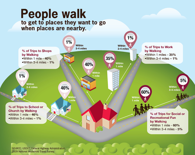
  • Walkable communities result in more physical activity.
More people are walking, but just how many depends on where they live, their health, and their age.
  • The West and Northeast regions have the highest percentage of adults who walk in the country, but the South showed the largest percent increase of adults who walk compared to the other regions.
  • More adults with arthritis or high blood pressure are now walking, but not those with type 2 diabetes.
  • Walking increased among adults 65 or older, but less than in other age groups.
People need safe, convenient places to walk.
  • People are more likely to walk and move about more when they feel protected from traffic and safe from crime and hazards.
  • Maintaining surfaces can keep people who walk from falling and getting hurt. This also helps wheelchairs and strollers and is safer for people with poor vision.
  • People need to know where places to walk in their communities exist that are safe and convenient.
  • Walking routes in and near neighborhoods encourage people to walk to stops for buses, trains, and trolleys.

Traffic Control Plan and Update for E. Stadium Bridges and State St.

E. Stadium Boulevard Bridges Replacement Project
August 11, 2012

Location and Limits of Affected Area:
E. Stadium Boulevard from Kipke Drive to S. Industrial Highway
S. State Street from Stimson to Granger Avenue

Description of Work:
Hot mix asphalt paving on S. State Street.

Temporary Construction Traffic Control Plan:

August 11, 2012 – August 12, 2012 (Northbound S. State Street)
Northbound S. State Street will be temporarily closed to vehicular traffic from Stimson to Granger Avenue. A detour route will be posted.

Southbound S. State Street vehicular traffic will be maintained at all times.

All vehicular traffic on S. State Street will return to its normal configuration at the end of the work day on August 12, 2012.

E. Stadium Boulevard between Kipke Drive and S. Industrial Highway will remain closed to pedestrian and vehicular traffic until November 14, 2012 to allow for the removal and replacement of the E. Stadium Boulevard bridges over the Ann Arbor Railroad and S. State Street. Vehicular and pedestrian detour routes are in place.

We thank you in advance for your patience as these necessary public infrastructure improvements are completed.


E. Stadium Road Work


Notice of Temporary Traffic Control Plan

E. Stadium Improvement Project

(Packard St to Brockman Blvd)
August 13 - 20, 2012

Location and Limits of Affected Area:
E. Stadium Blvd. between Packard Road and Brockman Blvd.

Description of Work:
The E. Stadium Improvement Project included the installation of a new 8-inch water main on the north side of the street and another new 8-inch water main on the south side of the street, between Packard and Brockman. Now it is time for the reconstruction and resurfacing of the street which will be completed during several phasing. In the week of August 13, 2012, contractors will reconstruct the south side of E. Stadium Blvd, from Packard through the intersection of Brockman.  

The remaining work that will follow this construction phase of construction will include the road construction on the north side, road construction at the intersection of E. Stadium Blvd and Packard St, road construction at E. Stadium Blvd between Brockman Blvd and Washtenaw Ave, and at the end the final layer of the asphalt pavement over the entire length of the construction area.     

Updated Temporary Construction Traffic Control Plan:
Beginning on Monday August 13, 2012 and for the duration of this phase of the road construction, one lane of traffic in each direction will be maintained at E. Stadium Blvd. between Packard St and Brockman Blvd.

During the road construction at the south side of the intersection of E. Stadium Blvd and Brockman Blvd, the through traffic on Brockman Blvd will be detoured through E. Stadium Blvd, St Francis Dr, and Winchell Dr. Pedestrian traffic will be maintained on both sides of E. Stadium Blvd during this phase of construction.

Project Information:
To maintain the safety of all, please reduce speeds and drive cautiously through work zones. We thank you in advance for your patience as these necessary public infrastructure improvements are completed. For more information about the project please visit our website at www.a2gov.org under the section for the Project Management or the Engineering Unit.

Project Contacts:

City of Ann Arbor

Igor V. Kotlyar, P.E., Project Manager (734) 794-6410 x43634 or at ikotlyar@ a2gov.org
Doug Egeler, Civil Engineering Specialist, (734) 476-4533

Dan’s Excavating, Inc.
Denis Rozanski, Project Manager, (810) 217-0187
Tim Forys, Construction Supervisor, (810) 217-1012

Washington St Road Work

Notice of Temporary Traffic Control Plan
Saturday August 4, 2012; 8:00 A.M. to 5:00 P.M.

Location and Limits of Affected Area:

E. Washington from S. Main Street to S. Fourth Ave

Description of Work:
This temporary street closure is for placing a large crane on E. Washington St. and lifting a communication cabinet to the roof top at 201 S. Main Street, at the corner of E. Washington St. Pedestrian traffic will be maintained on the north side of E. Washington.

Temporary Construction Traffic Control Plan:

The eastbound traffic at the intersection of S. Main Street and E. Washington will be detoured south on S. Main Street, east on E. Liberty Street, north on S. Forth Ave and back to E. Washington . The westbound traffic at the intersection of S. Fourth Ave and E. Washington Street will be detoured south on S. Fourth Ave, west on E. Liberty, north on S. Main Street and back to E. Washington.


S. University Construction

Notice of Temporary Traffic Control Plan
Saturday August 4, 2012; 8:00 am to 5:00 pm

Location and Limits of Affected Area:
S. University Ave, from S. Forest Ave to Washtenaw Ave

Description of Work:
This temporary street closure is for placing a large crane on S. University Ave and lifting building material to the roof top of the new building at 601 S. Forest Ave at the corner of S. Forest Ave and S. University Ave. For the public’s safety the road will be closed to vehicular traffic. Pedestrian traffic will be maintained on the north side of S. University Ave.

Temporary Construction Traffic Control Plan:

The westbound traffic at the intersection of S. University Ave and Washtenaw Ave will be detoured west on Washtenaw Ave, south on S. Forest Ave and back to S. University Ave. The eastbound traffic at the intersection of S. University Ave and S. Forest Ave will be detoured north on S. Forest Ave, east on Washtenaw Ave and back to S. University Ave.


Excellent Commuting Data Resource

This week, several WATS staffers are attending the Michigan Transportation Planning Association (MTPA) conference in Holland.  Basically, its a chance for Michigan's transportation geeks to meet and share some of the cool things going on around the state.  On Tuesday, staff attended a session with a resource that we'd like to pass on to our blog readers.  The American Association of State Highway and Transportation Officials (AASHTO) provides an excellent data source called the Census Transportation Planning Products (CTPP).  AASHTO partnered with all of the states on pooled fund projects to support the development of special census products and data tabulations for transportation. These census transportation data packages have proved invaluable in understanding characteristics about where people live and work, their journey to work commuting patterns and the modes they use for getting to work.

Access to this data is free and located at this link.  Keep an eye out for updated mapping functions and new data. The website has a learning curve, but tutorials will familiarize you with the interface.

Shape Michigan's Transportation Future


On August 2, 2012, help shape the future of transportation in Michigan at Ann Arbor SPARKTransportation for Michigan (Trans4m) is holding a series of community forums where citizens, business owners, and policy makers can work together begin crafting a vision for Michigan's transportation system.  See the poster below, or the event listing on the Trans4m website for more information.

New Ann Arbor Non-Motorized Transportation Blog

If you are interested in local non-motorized transportation news, articles, and events, check out the new Ann Arbor Non-Motorized Transportation Blog.  About the blog:
As the City of Ann Arbor prepares to update its Non-Motorized Transportation Plan this year (last done in 2007), it is time to not only see how far much infrastructure we have built, but also how much our city's culture has changed. Here is a place to collect videos, photos, and news items that help to piece together all the wonderful things that make Ann Arbor's culture of non-motorized transportation unique and worth CELEBRATING! For more information on non-motorized transportation in Ann Arbor please visit www.a2gov.org/WalkBikeDrive and www.a2gov.org. If you are interested in submitting a photo to the blog, or to learn more about the blog please email kknapp@a2gov.org.

Click this link to visit the blog.

Comparing Worldwide Bus Rapid Transit Systems

Each day world wide, more than 23 million individuals use Bus Rapid Transit (BRT) for their commute.  As a lower cost alternative to high capacity rail, BRT systems are an excellent choice for communities to maximize transit capacity and optimize use of existing road infrastructure. The system might be familiar to those who have visited Downtown Cleveland, where a BRT system, the HealthLine, has operated since 2008. For those interested in BRT systems, we stumbled on an interesting map from EMBARQ and the Bus Rapid Transit Centre of Excellence.  The map compares BRT ridership by continent, nation, and city.  See the screenshot below or click the link to see the interactive map.  See this wikipedia article for more information about BRT.

Interactive Map at BRTdata.org

From BRTdata.org
There is growing interest and demand for the high-quality bus systems as cities seek low-cost, sustainable urban transportation solutions. As the number of systems in the world increases, current, accurate and complete information about existing and planned systems becomes increasingly important but difficult to collect.

The goal of BRTdata.org is to improve the sustainable transport community's access to reliable and current data about the BRT and bus corridors currently in operation. We aim to improve the quality and impact of the industry by opening up access to data about the design, performance and cost of these systems. The platform provides a convenient repository of data from a variety of sources including researchers, transit agencies, municipalities and NGOs.